Antes de se chamar Ulaanbaatar esta cidade teve vários nomes, com diferentes significados e origens, e várias localizações, afinal a sua população era nómada.
Desde sempre localizada entre a rota comercial que ligava a Rússia à China, absorveu as diferenças culturais destas duas civilizações. Ainda hoje nos mercados encontramos produtos quer da europa, quer do extremo oriente.
E agora uma sucessão de representações da cidade, organizadas cronologicamente, que remontam há dois séculos atrás, para uma pequena analise cartográfica da evolução da malha urbana.
Pintura do século XIX, no centro está representado o templo Bat Tsagaan, construído em 1654.

Mapa geral de 1851.
Fotografia da área centra da cidade em 1888.

1912
Impressionante ver estas imagens da cidade de há um século atrás. E imaginar a vida da população, o interior das habitações, das yourtes, dos palácios, dos templos... Todas as imagens são excertos da pintura (4 ver lista no final).
"
The large circular compound in the middle is the Zuun Khuree temple-palace complex."
"T
he circular compound to the far left is the Gandan complex."
"Between these two circular compounds is the Baruun Damnuurchin markets."
"The temple complex in the cross shaped fence is the Choijin Lama monastery."
 "To the right of it is the mixed district of the South-East Lay Quarters (Zuun Omnod Khoroo) with the plantations."
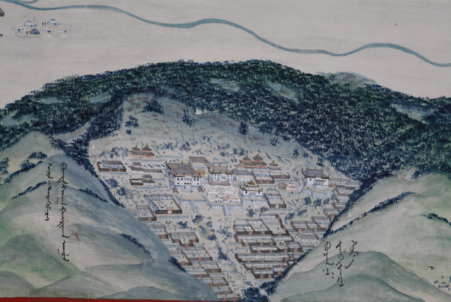 "The Manjusri monastery can be seen on Mount Bogd Khan Uul at the bottom of the painting."
A partir daqui, começa a ser confuso, mas tens a legenda completa em baixo. [Alguma dica?]
Legenda:
"Panorama of Urga painted by Mongolian painter Jugder in 1913. The large circular compound in the middle is the Zuun Khuree temple-palace complex. The circular compound to the far left is the Gandan complex. Between these two circular compounds is the Baruun Damnuurchin markets. The mixed district on the south of these three is the South-West Lay Quarters (Baruun Omnod Khoroo). On the south of the river are seen the palaces of the Bogd. The temple complex in the cross shaped fence is the Choijin Lama monastery. To the right of it is the mixed district of the South-East Lay Quarters (Zuun Omnod Khoroo) with the plantations. Just across the river to the right is the Zuun Damnuurchin markets. To its north is the Zuun Khoroo of the Bogd's Ikh Shavi. To the far north is the Dambadarjaalin monastery. The Manjusri monastery can be seen on Mount Bogd Khan Uul at the bottom of the painting. To the far bottom right of the painting is the Maimaicheng district. To its left are the white buildings of the Russian consulate area. The Tuul River can be seen flowing at the very bottom of the painting. This painting is well known in Mongolia and is famous for its attention to detail. The names on it were written in Mongolian by Jugder."
E não podia faltar uma vista área mais atual da cidade Ulaanbaatar;
Links:
2-
http://www.mongols.eu/maps-of-mongolia/historical-maps/
https://buddhistartnews.wordpress.com/category/mongolia/page/5/
4-
http://masterpieces.asemus.museum/masterpiece/detail.nhn?objectId=11220
Para ler:
A Tour in Mongolia by Beatrix Bulstrode:
http://digital.library.upenn.edu/women/bulstrode/mongolia/mongolia.html
 Mapa geral de 1851.


Sem comentários:
Enviar um comentário